To read the article by historian Ann Longmore-Etheridge, click here.
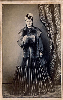
Louisa Linebaugh was one of nine children, all born in Myersville. The years between 1860 an 1870 altered everything Louisa knew. At the start of the decade, she lived in a bustling family with every indication of prosperity—even in wartime, as her exuberant mid-1860s teenage fashion shows. But shortly after this carte de visite was taken, on 26 December, 1864, her father died at the age of 57, and the family in Myersville rapidly dispersed.
To read the article by historian Ann Longmore-Etheridge, click here.
0 Comments
Peter Recher arrived in America in 1751. We know nothing of Recher’s life until his decision to immigrate to the Colony of Pennsylvania in 1751, when he was an unmarried 27-year-old. Remarkably, two letters sent by Recher to his family in Ziefen were translated and published by Klaus Hein in the October 1992 issue of Mennonite Family History. The first letter, written in 1751 provides a full and harrowing description of the effort it took to reach the ship Queen of Denmark on the English Isle of Wight then make the ocean crossing to Philadelphia. Recher would lead a full life in Pennsylvania and Maryland, where he settled in Wolfsville, dying there in 1791. He was the second person buried in Jerusalem Cemetery. To read the entire article by Ann Longmore-Etheridge, click here. From the Washington Post, 12 August, 1993
By Deb Reichmann MYERSVILLE, MD. -- Like a ghost from the early 1900s, trolley car No. 150 slides silently along the former Hagerstown & Frederick Railway route that runs through C. Donald Easterday's back yard. It is not really moving. Because of an illusion, the 75-year-old trolley with peeling aqua paint appears to be gliding along tracks where Easterday has showcased his piece of transportation history. The best place to spot the illusion is from a hill on his 30-acre property near Myersville. Like a child with a new toy, the 59-year-old Frederick County Farm Bureau administrator drives his visitor in a golf cart down the trolley roadbed and up the hillside. "I've had quite a number of people who say, 'Look at that trolley. It's moving,' " Easterday said. "I think they realize that it isn't. It's our position in relationship to the waiting station and the trolley. As we move, it gives the illusion that the trolley is moving too." The Hagerstown & Frederick Railway was typical of hundreds of electric trolley systems across the United States beginning in the 1880s. The trolley system, founded in 1893, linked Hagerstown and Frederick with Shady Grove, Pa., and the Western Maryland communities of Williamsport, Beaver Creek, Boonsboro, Braddock Heights, Jefferson, Middletown, Myersville and Thurmont. Ridership on the trolley system started to wane in the late 1920s as more automobiles brought about better roads. Freight traffic, however, remained steady. "It carried a lot of cantaloupes from Boonsboro to market," Easterday said. To read the entire article, click here. By Dr. Harold Moser From The Valley Register, 7 December, 1984. The article has been edited for clarity. It is likely that Myersville is named after a Stottlemyer -- probably the immigrant David Stadelmayer, who was born in Munich, Germany, 11 August, 1732. He arrived here in 1750. He died in February 1791. David Stadelmayer is thought to have been the first Stottlemyer to arrive in what would become America. He came aboard the ship Patience, whose captain was Hugh Steele, having sailed from Rotterdam, The Netherlands, to Cowes, Isle of Wight, England, and then on to Philadelphia, Pennsylvania, in the English Colonies. An Oath of Allegiance was taken upon disembarking at the Philadelphia Courthouse on Saturday, 11 August, 1750, which was preserved in official documents: "Present: Thomas Lawrence, Esq., Mayor. The foreigners whose Names are underwritten, imported in the ship Patience, Capt. Hugh Steel, from Rotterdam, but last from Cowes in England, did this day take and subscribe the usual Qualifications. 124 By List. 266 Freights. ...David Stadelmayer..." The 1910 History of Frederick County Maryland by T. J. C. Williams, explores the Stottlemyer ancestry, beginning with Henry F. C. Stottlemyer then regressing to his great-grandfather David, the immigrant. Afterward, the text describes David Stottlemyer, Jr., grandfather of Henry, and finally Henry's father, Daniel Stottlemyer. "Henry F. C. Stottlemyer, a retired farmer residing in Catoctin District, Frederick County, Md., one mile northeast of Wolfsville, son of Daniel and Johanna (Recher) Stottlemyer, both deceased, was born on that part of the old Stottlemyer homestead on which he now resides, April 22, 1842. "David Stottlemyer, great-grandfather of Henry F. C. Stottlemyer, who was born and educated in Munich, Germany, came to America in early manhood and settled in the southwestern part of the Middletown Valley. He was one of the early settlers of that section of Maryland where the remainder of his life was spent. He married and had five children among whom was a son named David. "David Stottlemyer Jr., son of David and Margaret Stottlemyer, grandfather of Henry F. C. Stottlemyer, was born and grew up on a farm near Middletown, Md. He was a farmer and miller, and owned the property now known as the Keller Mill farm, near Middletown. Mr. Stottlemyer afterwards sold this place and bought a large tract of farm and timber land near Wolfsville, Md., where he spent the rest of his life. He was successful both as a farmer and as a miller, and was highly respected as a citizen. David Stottlemyer, Jr., was married to Margaret Maugruter. Of their eight children six reached adult age: 1. and 2. Jason and John, twins, both deceased; 3. David, deceased; 4. Daniel; 5. Joseph, deceased; 6. Margaret, deceased, married to the late George Lizer. Mr. Stottlemyer and his wife were members of the Reformed Church. "The late Daniel Stottlemyer, father of Henry F. C. Stottlemyer, was born in September 1796, on a farm in the Middletown Valley, northwest of Middletown. He grew up on his father's farm, and remained on the home place until his father died when he inherited the part of the homestead now owned by his son, Henry. Mr. Stottlemyer made many improvements on the property and afterwards bought a farm of 60 acres, now the property of Daniel Harshman. This place also he improved, putting up a dwelling, a barn and all other necessary buildings. Some time later, he purchased 56 acres of farm and timber land, making his holding to consist of 300 acres. He was a skillful farmer and improved all the land that came under his care. His toil and patient care were richly rewarded. Mr. Stottlemyer was a Democrat, highly esteemed as a business man, and citizen. Daniel Stottlemyer was married to Johanna, daughter of John and ______ Recher. Of their thirteen children, ten reached maturity: 1. Jonathan, a farmer of Washington County, Md.; 2. Joseph, deceased, a farmer of Catoctin District, Frederick County, Md.; 3. Rosanna, widow of Daniel Biser; 4. Elias R., a retired farmer of Cavetown, Washington County, Md.; 5. Frederick, a retired farmer of Wolfsville, Md.; 6. Leah, deceased, married to the late Silas Buhrman; 7. Mary E., deceased, married to William Troxell, of Illinois; 8. Margaret A.R., widow of Lawson Palmer of Easton, Pa; 9. Lydia, deceased, married to the late William Hauver; 10. Henry F. C. "Mr. Stottlemyer was a member of the German Baptist Church. His wife held membership in the Reformed Church. Mr. Stottlemyer died on April 21, 1874; his wife on July 5, 1895. "Henry F. C. Stottlemyer was educated in the public schools of Catoctin District. He remained on the home place and after his father's death inherited the farm he now owns as his share of the estate. This farm, the old Stottlemyer homestead, is a valuable property. It is beautifully situated on the Foxville road, one mile northeast of Wolfsville. Mr. Stottlemyer has greatly improved the place. He remodeled the dwelling, added a second story, built a fine bank barn, and put up all the necessary farm buildings. His well-merited success is due to his faithful labor, and constant care. He is a Democrat, interested in county affairs, and is well-known and highly esteemed in the district. "Henry F. C. Stottlemyer was married to Martha E., daughter of William B. and Elizabeth (Fox) Brown, whose father was a prominent farmer residing near Foxville. They have four children; 1. Worth B., teller in the Bank of Waynesboro, Waynesboro, Pa., and Treasurer of the Chambersburg, Greencastle, and Waynesboro Street Railway Company, Waynesboro, Pa.; 2. Claud U., General Manager for the Geiser Manufacturing Company at Louisville, Ky.; 3. Olga D., at home; 4. Irma M., at home. Mr. Stottlemyer is a member of the Reformed Church in Wolfsville, and is a liberal contributor to both church and Sunday School. He has served the congregation as deacon, and is now an elder and the Superindendent of the Sunday School." (It is believed that the “Foxville Road," mentioned in the second to last paragraph, is today's Stottlemyer Road that leads to Foxville.) It was in the geographic area of Middletown/Myersville/Wolfsville that the Stottlemyer mills, operated first by David & Maria Stadelmayer, and then by their children were situated. In fact, the Point Rock Mill's last owner was Marcellus Duvall whose wife, Cornelia Stottlemyer Duvall, was the great-granddaughter of our George Stottlemyer, son of David Stadelmayer the immigrant." By Dr. Harold Moser
From the the Valley Register, 7 December, 1984 From 1785 to 1885 much of the industrial and social life In Frederick County was built around its grist and flourmills. Over this span of years the production of wheat, corn, oats and barley increased in volume and this rapid increase in grain cultivation was followed by the construction of an astonishingly large number of small grist and flour mills. When Charles Varle prepared his 1808 map of Frederick County he found 104 grist mills operating along the streams of the county. It seems that along every possible stream where waterpower could be tapped there emerged a swarm of small mills; one fairly recent Inventory has identified as many as 67 mill sites used at one time or another along the Catoctin Creek and its tributaries. Mills that serve a common function and which also are constructed of local building materials are almost certainly going to be similar in appearance and so it is not too surprising to discover that most of the early, small mills were almost as much alike in appearance as the grains of wheat they milled. Any man who owned a mill site and had wood and stone to build the Mill could become a miller. In each Instance a stream was dammed to create a millpond that could be tapped when the mill was used. When the gate were opened water poured into the millrace and turned the big wheel. As the waterwheel went around gears spun an axle to which the millstones, in their boxed enclosure, were attached. Wheat went into the top and came out ground at the bottom. Finally the bran was separated from the flour. No mill of the Varle era is known to be still operating In Frederick County. However there were 70 water-powered grist mills actively processing grain in 1850 and the Titus map of Frederick County in 1873 Identifies 77 such mills. Among the water-powered mills still operating in 1910 the Point Rock Mill, about 4 miles above Myersville along the Easterday Road. Perhaps came closest in size and general appearance to the many small mills that were built about the time of the Voris survey. This small mill tucked away among the hills of the Catoctin District survived the competition of many larger mills in the county until the very end of the era of mills powered by water. From 1881 to 1925 this mill was known locally as the Duvall mill. Its historical uniqueness was recognized at the beginning of the Twentieth Century and a postcard was designed bearing its likeness. The reproduction of the mill appearing in this article is an enlargement from one of these cards in the collection of Mrs. Leah Spade of Wolfsville. The photograph reveals all the salient features of one of these early mills. The stream is the little Catoctin. The dam, millpond, sluice and water wheel are clearly shown. The metal water wheel shown here is a refinement over the wooden water wheels used by the earliest mills. Metal water wheels were introduced during the 1880's and so this improvement must have been added by Marcellus Duvall. The earliest known owner of this mill was George Marker (1756-1827). He may have been the builder but conclusive evidence to support such a claim has never been found. George Marker is known to have, operated the mill between 1816 and the time of his death in 1827. Jacob Palmer owned the mill between 1839 and 1866 and under his management the mill enjoyed its most prosperous years. By 1850 the mill was processing annually 8000 bushels of grain and turning out 1100 barrels of flour. Miller Palmer added a sawmill to the operation and he employed three laborers to help run the plant. The prevailing wage for a sawmill assistant was $16 per month. Mill hands were paid $20 per month. The mill barely survived the economic depression in the early 1870's. Mill ownership changed three times between 1866 and 1881 and finally, on April 4, 1881, the mill was sold to Marcellus Duvall who was the last Miller to operate the Facility. At 45 years of age he was an experienced miller coming from a family of millers. However, his experience and skill asa miller were not enough to overcome the tide of change that was sweeping the milling industry. Improved transportation and the emergence of large urban milling centers gradually brought to an end the era of local, water-powered grist and flour mills. In 1903, at the age of 67, Marcellus Duvall had the ownership of the mill transferred to his wife, Cornelia (Stottlemyer) Duvall. The mill property remained with the Duvall family until 1926 (Marcellus died In 1925) but the mill must have ceased operation a number of years before the property was sold. Today only a small fragment of a mill wall remains to mark the site of the once busy center. Neighbors report that much of the mill area has been destroyed by vandals. Dense undergrowth now borders the headwaters of the Catoctin creek and a fine country home now stands at the place where the miller once lived. by Nancy Bruce In our earliest years, circuit riders traveled through specific areas to minister to settlers and organized groups. These traveling ministers on horseback carried only what would fit into their saddlebags. They traveled through wilderness and villages. They traveled through snow and rain. They preached nearly every day at any place available, fields, homes and barns. Sometimes their circuit was so large it would take weeks to cover. The Methodist Episcopal Church was the largest denomination in America during the 1820s. This was largely the result of the circuit riders, or traveling ministers. One of these circuit riders was Rev. Moses Hurley, who owned land in the Wolfsville-Garfield area. When Rev. Hurley left the circuit he united with the Winebrennarian Church which may have been located where the Bethel Church now stands. Another circuit rider was Rev. Christian Newcomer. He was an evangelist for the United Brethren Church. The Hoover home in Wolfsville was the regular preaching place for the circuit rider. As the country grew and congregations became well established, churches flourished with their own clergy and the circuit was no longer needed. The Maryland Historical Trust was established in 1961. The state agency is dedicated to preserving the legacy of Maryland’s past to help us understand our historical and cultural heritage. A site goes through a varied investigative process to understand, recognize and develop a record of its past and present appearance, history, and significance.
These are the Myersville-Wolfsville area sites currently listed on the Maryland Historical Trust Inventory of Historic Properties: Ellerton/Harmony Benjamin Shuff Farmstead, circa 1865, 4349 Middlepoint Road Ellerton Survey District, circa 1865-1900, rural village with a general store, creamery, blacksmith shop and steam engine Enos Doub Farmstead, circa 1840, 9202 Myersville Road Grossnickle, Peter of P. Farmstead, circa 1840, 11720 Wolfsville Road Grossnickle Church of the Brethren, 1889, 11301 Meeting House Rd Grossnickle Farmstead (Oakland Mills), 9120 Harmony Road Harmony Survey District (Beallsville), circa 1890, consists of 25 acres including a woolen factory Harshman-Frushour Farmstead (H & F Trolley Shelter), 111423 Meeting House Road Highland School, 10539 Highland School Road Jacob Leatherman Farmstead, circa 1850, 12348 Wolfsville Road Jacob Zentmyer Farmstead, circa 1830, 112031 Pleasant Walk Road John Grossnickle House, 11353 Highland School Road Josephus Palmer Farmstead, circa 1860, 11317 Church Hill Road Koogle Farmstead, circa 1820,10513 Grindstone Road Schlosser-Waters Farmstead, circa 1830, 9232 Harmony Road Myersville/Church Hill/Pleasant Walk Christian Moser House and Barn (above), circa 1830, 1914 Monument Road Church Hill Survey District, circa 1830-1915, district includes the church, the Old School, and several homes that exemplify the development of rural communities. Daniel Palmer Homestead, circa 1820, 3813 Crow Rock Road David Stottlemyer Farmstead, circa 1810, 12719 Stottlemyer Road Doub-Routzhan Farmstead, circa 1840, 10412 Church Hill Road Easterday-Summers Farmstead, circa 1863, 10916 Church Hill Road Mount Olive United Brethren Church (now Pleasant Walk United Methodist), 11240 Pleasant Walk Road, Myersville Myersville Survey District, Myersville, Main Street properties. Ostertag Farm, circa 1800, 111847 Easterday Road Pleasant Hill, circa 1841, Myersville Road Ramsburg-Gaver Farmstead (Shelter Rock Farm), 4234 Crow Rock Road Recher-Morgan Farmstead, 12707 Brandenburg Hollow Road Rout-Smith Farmstead (The Seven Partners), circa 1810, 11025 Pleasant Walk Road Shank-Ridgley House, circa 1920, 2448 Canada Hill Road Smith-Bowlus Farmstead, circa 1862, 2812A Monument Road Stottlemyer-Harshman Farmstead, circa 1850, 11192 Wolfsville Road William Green Farmstead, circa 1800, 11134 Rum Spring Road Grossnickle Tenant Farm, 9120 Harmony Road Edgar M. Frushour Homestead, 11912 Wolfsville Road Kuhn Log House, 14022 Wolfsville Road Echo Lake Stone House, Camp Echo Lake Road Pleasant Hill, Myersville Wolfsville Wolf Sears Catalog House, 3530 Garfield Road Jacob Leatherman Farmstead, 12348 Wolfsville Road David Stottlemyer Farmstead, 12719 Stottlemyer Road by Nancy Bruce
Passed in 1966, the National Historic Preservation Act established the National Register of Historic Places. This is the official list of districts, sites, buildings or structures and objects which are worthy of preservation. The National Register is administrated by the National park Service, an agency of the Department of the Interior. The Park Service helps individual property owners and interested groups identify and protect these historic sites. There are 1,500 sites in Maryland listed on the Registry. Ninety five of those are found in Frederick County. Only one is located in our area. In 1998, the Peter of P. Grossnickel Farm was added to the Registry. Its historical significance is in the architecture and engineering and distinguished by the collection of out buildings. It is located on the tract of land known as “Six Daughters” purchased by Bernhard Grossnickel. The Grossnickel family was among the early German families who settled in the area in the mid 19th century. The date of construction is listed as between 1840-1850. You can read the entire survey here and view the Maryland Historical Trust page about the property here. Photo: Harmony Road Bridge, Harmony Road spanning Little Catoctin Creek, Myersville, Frederick County, Maryland. Courtesy Library of Congress. Bridge National Pike 40 over Catoctin Creek
Bridge National Pike 40 over Middle Creek Bridge Wolfsville Road 17 over Middle Creek Bridge Myersville Road 17 over Catoctin Creek Bridge Road 17 over Little Catoctin Creek Church Hill Bridge East Church Hill Rd. over West Branch Crow Rock Bridge Crow Rock Road over Middle Creek Ellerton Road Bridge Harmony Road over West Branch Harmony Road Bridge Harmony Rd ov. Little Catoctin Creek Hollow Road Bridge Hollow Rd over Little Catoctin Creek Old Harmony Rd. Bridge Harmony Rd ov. Little Catoctin Creek Mary Rose Boswell, executive director, Historical Society of Frederick County, wrote an article on this postcard and its sender for Frederick Magazine. You can read it here. |
AuthorsArticles and research by members of the Myersville-Wolfsville Historical Society Archives
September 2022
|